|
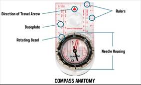
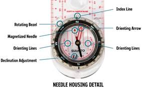
Using map and compass home | hiking list | places | 40 places | trip prep with weights | knots | wilderness medicine Using map and compassParts of a compass—note that the instructions are for a compass without declination adjustment.
Introduction—instructions with most compasses have methods based on fundamentals; we present only fundamentals. Holding the compass—the base plate should be kept and remain horizontal. What the declination is—the angular deviation of magnetic North from true North, East or West. Find a direction—first rotate the compass so that the red end of the needle points to the declination on the bezel. North on the bezel is now true North. Other directions are given by the angular scale. The bearing of an object is its direction or angular orientation, measured clockwise from 0° to 360°, i.e., degrees East of North. Find the bearing of an object—first orient the map North – South. Given your position on the map (see the next step), bearings of objects can be read from the map. Or, Orient the compass North – South. Read the bearing of an actual object. Finding a position on the map (first orient the map N-S)—for a known visible landmark on the map, this is not a problem. Given a trail, stream, or other known line, and a known object, find where the bearing of the object intersects the line. Given two known objects, find where their bearings intersect. For accuracy, the difference between the bearings should be between 60° and 120°. Using a topographic map—a contour is a line of fixed elevation. Closer lines mark steeper. Given a series of V lines, it is (i) a ridge if the elevation decreases in the direction of the point of the V (ii) a stream bed if the elevation increases in the direction of the V. Mountains are marked by concentric closed lines. |